This river is a narrow and in places fast flowing river that comes up at the same time the Clare Glens is up. Expect a number of natural slides and plenty of trees.
The run is about 3km long. At the get in, under the bridge, there is good potential for a park and play spot when the water is high. A hole forms here with a foam pile.
There are a number of natural slides on the river. None are particularly difficult. Waves that can be surfed form every so often on the river. There are a lot of over hanging trees on this river.
A solid roll is essential in medium/high water as the water travel very quickly over rocks. This river has good potential at high levels, and should be considered if the Glens is too big to be paddled.
Trees, trees and more trees. Be ready to help someone that is pinned either in trees or on rocks. A few under cuts to watch out for, especially near the slides. There are very few large eddies/pools on this river so swims wont be pleasant. Also theres two lines of barb wire going accross the river about half way down so watch out,but its easy enough to limbo under it in low water.
- Be carefully when parking at the bridge at the get in.
- There is no sign of fishing on the river.
- Unfortunately litter lines the banks as you get close to Newport.
Loading levels...
Written by paddlers. If you know this river, sign in and edit these notes. Changes are reviewed before they appear.
At the bridge in the village, if the run looks low there it will be scrape the whole way down. If the water is brown and trees a flowing buy, take care.
Typical number of days each month the river is at a paddling level
| Month | Typical paddle days | Driest year | Wettest year | Years with at least one paddle day |
|---|---|---|---|---|
| January | 9 | 5 | 12 | 8 of 8 |
| February | 9 | 1 | 21 | 7 of 7 |
| March | 6 | 0 | 12 | 7 of 8 |
| April | 4 | 0 | 10 | 6 of 8 |
| May | 1 | 0 | 4 | 5 of 8 |
| June | 1 | 0 | 4 | 5 of 8 |
| July | 0 | 0 | 7 | 3 of 8 |
| August | 1 | 0 | 11 | 4 of 8 |
| September | 3 | 1 | 7 | 8 of 8 |
| October | 9 | 1 | 20 | 7 of 7 |
| November | 12 | 3 | 17 | 8 of 8 |
| December | 12 | 3 | 18 | 7 of 7 |
The best months on the Mulcair/Newport are January, November and December, with 9 to 12 paddle days in a typical month. Summer is hit and miss: a typical June to August month gives only about 1 paddle day, but July had at least one paddle day in 3 of the last 8 years.
How to read this graph. A paddle day is a day the gauge reached between the guide's Low and High levels (0.8 to 1.5 m). Each bar is the middle year of 8 (2018 to 2026). Tap a bar for the driest and wettest years.
How high the river usually gets each day, from 8 years of readings (2018 to 2026)
| Month | Typical daily high | 8 days in 10 between |
|---|---|---|
| January | 0.765 m | 0.526 and 1.94 m |
| February | 0.986 m | 0.518 and 2.358 m |
| March | 0.769 m | 0.47 and 2.17 m |
| April | 0.483 m | 0.381 and 1.0 m |
| May | 0.411 m | 0.337 and 0.603 m |
| June | 0.385 m | 0.331 and 0.652 m |
| July | 0.379 m | 0.318 and 0.866 m |
| August | 0.398 m | 0.304 and 0.971 m |
| September | 0.49 m | 0.327 and 1.202 m |
| October | 0.817 m | 0.456 and 1.854 m |
| November | 1.018 m | 0.477 and 1.929 m |
| December | 1.048 m | 0.558 and 2.031 m |
How to read this graph. The line is the typical daily high; the shaded band covers 8 days in 10. Dashed lines are this guide's levels.
Past levels are no guarantee of future conditions. Readings can be late or wrong: check the river on the day. Level colours, "Running now" and paddle days are a guide only, not a sign that the river is safe to paddle. Read about gauge data and levels.
Levels for this guide: whitewater.guide (CC licensed).
Contains Irish Public Sector Information licensed under a Creative Commons Attribution 4.0 International (CC BY 4.0) licence (source waterlevel.ie, provided by the Office of Public Works).
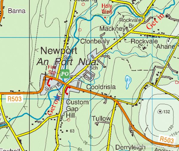
This stretch of the Mulcair is often called the Newport river as it flows through the village of Newport.
To go to the put in drive to Newport from the N7 direction, turn left after you go over the bridge in Newport village. Follow this road until you come to a bridge at a dangerous bend in the road. At this bridge you can park and get on here or walk up 100m upstream on river left.
The take out is in the village on Newport. You can go down the last slide in the town and get out on river left, or get out on river right just upstream of the last slide.
If you get out on river left there is a short path up to the road near the Garda station. There is plenty of parking around here.
If you get out on river right there is a small amount of parking behind buildings on the main street, look for the steep lane going down from this road just beside the bridge in the village.You cant miss these get outs as they are just after the bridge in the village.
Interactive map loading...
Newport river
Peter