There are four main defined sections of this river each around 12 miles in length.
At 192 km (120 miles), it is the second longest river in Ireland. So the river is broken into many different sections. If you touring its possible to cover a couple of different runs in the one day, but if your just out for a short paddle or guide a beginner group here they are broken into small sections.
Overview
Weirs on the Barrow starting at Athy and going to st Mullins are:
The weirs gradually get more frequent as you descend from Athy to St Mullins with them inicreasing in frequency as you go further down. The best stretch of river is from Clashganny to St Mullins which has 6 weirs 3 eel weirs (V's pointing downstream and 2 rapids), but if you have time getting in at Goresbridge will bring in another 4 weirs. Above Goresbridge things are less frequent up to Milford with only 7 weirs but over a reasonably long stretch. The best weir being Milford. Above this things are real slow with only 6 weirs but with much greater distance between weirs. General rule the further down to Mullins the better.
The Source
The source of the River Barrow is at Glenbarrow in the Slieve Bloom Mountains in County Laois. As far as I know this part of the river has not been run, but its possible a few people may have ventured up there. In Glenbarrow there are a few little drops and rapids, A forestry walk follows along side the river most up as far as its still interesting and provides easy access, A couple of old timber bridges similar to the bridge in Clare Glens cross the river at different points, visit the website of Glenbarrow Eco-Walk for good maps and nice pictures of the river in low water.
Theres plenty of flat stuff inbetween these with lots of lough gates and small waterfalls on the joining canals.
The first section section of any interest runs from Athy to Carlow. Long slow flay and very few weirs. The first part is slow with almost nothing to do but slog downstream for miles with weirs at Levitstown, Maganey and Bestfield until you come to Carlow (3 Weirs or one every 4 miles).
The next section from Carlow to Leighlinbridge also has long slogs staring with a weir in Carlow you then slog on past the only natural wier on the river: Clongrennan and to Milford Mills where things start to look up as this is a pretty reasonable weir (once breached and now repaired). Just upstream of the Cardinal Moran Bridge is Rathvinden Weir. Past this you will pass Leighlinbridge (4 weirs in 12 miles or an average of one every 3 miles). The third section starts here on runs to Ballytiglea Bridge.
Downstream of Leighlinbridge is Rathellin Weir. followed by Bagenalstown Weir which is a typical Barrow Weir but is around 10 or 11 feet in height but needs loads of water. A good distnace below this you will encounter Fenniscourt , Slyguff and Upper Ballyellin Weir which is upstream of Goresbridge and just downstream you will encounter Lower Ballyellin.
Finally in this moderately interesting section of the river you will encounter Ballytiglea Weir. Then you will reach Ballytiglea Bridge outside Borris which is the end of section three (7 weirs in 12 miles on one less than every 2 miles). When you pass Ballytiglea Bridge you will enter the fourth and most interesting part of the Barrow as it plunges into a deep valley and Weirs are more frequent and generally larger. The first is Borris Weir and then Ballinagrane. One of the best sections on the river then follows.
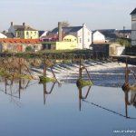
Clashganny
Possibly the besty run of the river for whitewater paddlers. The river hits a wier a short walk up from the carpark at Clash, then into lough gates beside the carpark into a large still pool. The wie is the start of this section you can get in above the gates and paddle up to the wier, Its a straight forward weir, about 4 or 5 ft high and sloping, in high water it can be kind of grabby but running as far river left as you can and you will be fine, in medium waters a small waves forms at this end.
Next its some easy fast/slow water depending on levels, to the second wier, far river right its a bit rock at the bottom, far river left its more striaght forwards, a small shoot gap in the top of the wier forms a wave at the bottom in low to medium high water. In super high water a very retentive bar stopper forms along the bottom of the wier, good to play for more experienced people.
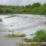
Next up is the rapid, a 100metre section of water that's littered with boulders and protruding rock that from the nicest piece of white water on the river, loads of spots to break out behind stuff and practise ferrying etc. Straight down the middle is the easiest line.
Next weir is a down river V weir with a Break at the bottom of the weir for a salmon fishing gate, with rigging for dropping nets. This is dodgy to paddle down as there is a chance a boat could get pinned sideways because its narrow, you can run either side of the arms of the weir from the top, both sides have small rapids. Thats about it, roughly 100 metres down stream on the left is the turn back into the canal, get out here and paddle back up to your car.
Touring paddlers could continue on to Graiguenamanagh.After the broken weir as described above its a nice scenic paddle to Graiguenmanagh all of which is on flat water. You will pass some swimming spots which will be packed during the summer months so best stay river left & give them their space.
The get off ramp / diving board in Graige gets massive traffic on nice days so please be respectfulll andclear the slipway for other users.
( will be edited into below soon)Under Graiguenamanagh Bridge is upper Tinnehinch Weir. Less than a mile on is Lower Tinnehinch Weir and another Eel Weir, another short distance below this you will encounter Carriglead Weir another reasonable rapid and another Eel Weir all close together. Finally you then slog down river a mile or more to St Mullins Weir, one of the largest on the river. The tide stops here, and one needs to be aware that on incoming tidesstoppers below this weir do not behave as normal. A nice weir but bear this fact in mind as there have been two fatalities here. Get out is in St Mullins village unless you fancy a long boring flat nightmare to New Ross and beyond.
Graiguenamanagh to St. Mullins
Another nice run for bringing groups. Get on the river at the carpark beside the rowing club clubhouse. At busy weekends the toilets are open here if you need them. There is a Diving board here too thats locked most of the time, but when is open its good for a laugh. There area lot of canal boats moored here, so mind the noise and antics getting on the river. Just below the road bridge between Graiguenamanagh and Tinnahinch is the first weir, a 2-3ft high weir that curves around with the river, easy enough to run shallow a lot the bottom for most of the width and a small wave at river right at the shoot in higher water. A long flat stretch to the first weir, A 3ft weir again curves along the river from bank to bank and is followed by a rapid, its quiet rocky on river left best bet is to run the shoot on river right and continue down the centre of the rapid. No biggy, plenty of bank access for re-running. Again a bi of a stretch to the next weir similar to the one at clash with the salmon gate, rapids on the left and right from the top.
Another long stretch and the best weir on this section, its about 4-5ft high very bouldery at the bottom and rescue might be needed, can be grabby in higher water, inspect and choose a line, on rive right theres a cool boof spot off the weir where a ledge ramps out from the weir.
Its another (I know!) long stretch to the weir above St. Mullins, the river is tidal up to the bottom of this weir, because of this it can be very tricky, in low water its very scrapy and rocky at the bottom, in high water and high tide a serious stopper forms and a couple of years (October, 2004) ago two paddlers drowned here when the river was in flood, so caution is important, if in doubt dont chance it. There are plenty of warning signs to tell you to give it a skip. If you getting out here there is forestry access road down to the waters edge, but it can be tricky to locate. You can also take the canal around and continue down to St. Mullins, from the weir down its flat and some lovely scenery. St. Mullins is quiet popular spot of swimming and sun bathing in summer and there's a shop and stuff so be nice and take care parking and getting changed lots of kids around.
This final twelve section has 11 weirs and 2 rapids (one every 1 mile or so).
Remainder
Again there's loads more on the river, mostly flat though, until it meets the Nore at Ballilogue and then flows through New Ross and meets the Suir at cheek point outside Waterford. the flat sections are well documented on a lot of rive cruising websites if you want to find out more Google a few words to do with any section and you get plenty of websites with photos and guides for canal boat trips.
Salmon fishing net gates on some of the wiers. River Debris, trees, old farm junk etc.
River Debris in high water can be everywhere, .
Large trees get caught on most wiers over the winter and often animal remains as there is lots of farm land along its path.
The weir above St. Mullins, the river is tidal up to the bottom of this weir, because of this it can be very tricky, in high water and high tide a serious stopper forms and two paddlers drowned here when the river was in flood, so caution is important, if in doubt just walk around via the lock gate on river left.
Read the MCIB report of that accident (PDF - 5.4MB )
No local issue that I am aware of, it is a very popular fishing river and your more than likely to meet fishermen who are always friendly and happy to see you, be polite and you will be fine.
The river rises and falls with the nature season being such a big river, the upper section need plenty of rain. During the winter it will be high and will drop of rising and falling through the spring till the summer when who knows what happens weather dependant.
The Barrow, one of the three sisters rivers formed by the Suir, Nore and Barrow. The source of the Barrow is in the Slievebloom Mountains in Co. Laois. The river is big and wide and has lots of canal boat action too. For the most part its flat and good for scenery but there are interesting runs too described below.
Your best bet is decide on a particular run below and take a look at the guide map, the main stops are all marked.
As already stated there are loads of different runs, the major stopping points where the road crosses it are marked on the maps, mains points would be St. Mullins, Graiguenamanagh, Clashganny, Carlow etc.
Interactive map loading...
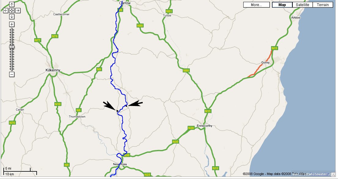
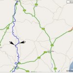
large map of barrow from carlow town to new ross river is in blue and clash and grauig are marked by arrows
michael flynn
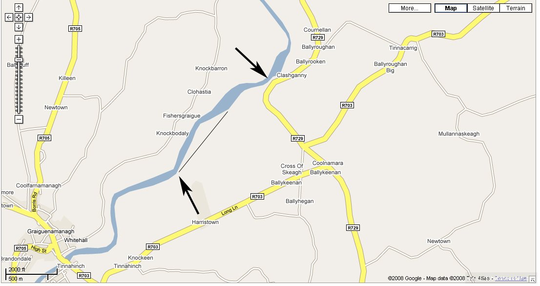
clashganny one arrow shows the get on at clash the lower ones is approx the get out and the line shows the side canal that you use to paddle back to the car park
michael flynn
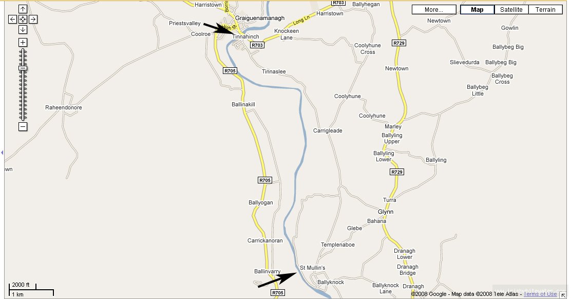
google of map of graignamanagh to st mullins run
michael flynn