
Forkhill River
| Grade: | 1 to 3 | Rating: |  |
|||
| County: | Armagh | Date updated: | 03/01/2008 | |||
| Section Length: | 3.5KM | Version: | 3 (History) | |||
Brief River Description
The Forkhill river is a nice little river which would be best suited to the intermediate paddler.Directions to the Put-in
From Dundalk town travel north crossing the Castletown bridge (the old stone bridge). Take the first left turn at the Lisdoo Arms Pub and head out the Armagh road R177. At Approx 2.5 miles take a right turn off the main road at a fork in the road where you see Kilcurry Church. From here you travel a further 2 miles crossing the border and into Forkhill Village. When you enter the village take a sharp left at Larkin's Pub and you will come to an old stone bridge. Look up stream - if the big rock on the right is covered the river is runnable.The get in is just downstream of the bridge.Directions to the Take-out
Head back towards Dundalk - at Kilcurry Church take two right turns to bring you onto the R177 Armagh direction and travel for approx 1/2 mile until you come to the Barley Corn Pub which is on the left. This is the best place to park - boats can be carried from the take out across the road to pub car park (approx 50 metres).River Description
At the put in the river is narrow and begins to pick up speed as it heads towards an old mill. At the mill the water constricts into a man made channel and then opens out into the start of the first white water section (Begley's Blast). At medium levels the rocks are only covered and can give an unpleasant surprise to the unsuspecting paddler. At higher levels the water is big and bouncy and fast for this 100 metre section (2/3).The river then slows down as it turns a corner before picking up to offer a few more smaller rapids(2).
Then the river loses much of its energy and narrows (1/2) as it crosses the border into Co. Louth. Watch out for a few low footbridges which can be limboed under with some care. About a mile further on at a sharp S bend in the river the next white water section begins. This is the best section of the run. The rapids are continuous for about 200 - 300 metres and include a few small drops.The biggest drop is about a 2 metre fall and is on river right over half way through this white water section. It's not difficult but is not very deep at the bottom so a boof stroke may save some plastic! There is a small stopper at the bottom that would merit some respect in very high water levels. After this section the river narrows and meanders to the finish point at a large stone bridge in a place called Kilcurry.
Note: The river does offer a few more white water sections and can be paddled into Dundalk to a section called Toberona - but the there are many trees blocking this section and at present it is not advised.
Local issues
There are no major local issues - the British Army once helicoptered down as we were heading down river. I think they knew what we were doing but just wanted a close up probably out of boredom as its been very quiet of recent time. The locals seem more amused and surprised when they see boaters on the river.River level gauge
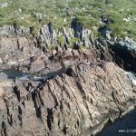
At the put in look up stream about fifty feet on the right. There is a big bolder a few feet from the bank. This needs to be well covered to make the river runnable. If it's not even visible and the water is going out into the field then it is very high and will be a fast and possibly 3 and because of the features on the river it will demand due respect. The Forkhill river rises fast after heavy rain but it also drops within a few hours after rains.
River Hazards
The river is narrow in places / a fallen tree may block the passage / barbed wire across the river in 2/3 places but only in the grade 1 sections and can be paddled over in high water / Low bridges / river is very rocky don't try to stand if swimming /Author(s)
Original Author: simon conroyLatest Author: simon conroy
(Full History)
Please add river details by adding to/editing the guide.