Galway, Connacht Grade: 1 - 2 4km
1.123 m rising No current reading or no levels set Out of dateDuring the winter the river floods the fields on its banks, sometimes the barbed wire fences can be covered with water.
The Fisheries Board have added a "fish counter" to the river just below the Kileelybeg bridge aka the third bridge. It comprises a weir with a shoulder high concrete channel in the direction of the flow. There is not much room upstream to get out and inspect, it has the potential to be a great tree gatherer, beware! The resulting stopper downstream may cause problems in high water.
I would advise a quick look before put in.
This guide has a gauge but no paddling levels yet.
If you have run it, you can help. Tell us the level it needs to be worth doing (Low), and the best and highest levels if you know them. Once an admin approves them, this guide gets level colours, a place in "Running now" and a count of paddle days per month.
Suggest levels for this guideLoading levels...
Written by paddlers. If you know this river, sign in and edit these notes. Changes are reviewed before they appear.
How high the river usually gets each day, from 8 years of readings (2018 to 2026)
| Month | Typical daily high | 8 days in 10 between |
|---|---|---|
| January | 1.125 m | 0.672 and 1.535 m |
| February | 1.207 m | 0.689 and 1.726 m |
| March | 1.146 m | 0.621 and 1.62 m |
| April | 0.837 m | 0.422 and 1.408 m |
| May | 0.629 m | 0.323 and 1.253 m |
| June | 0.667 m | 0.324 and 1.119 m |
| July | 0.72 m | 0.264 and 1.224 m |
| August | 0.938 m | 0.352 and 1.409 m |
| September | 0.925 m | 0.35 and 1.502 m |
| October | 1.114 m | 0.704 and 1.652 m |
| November | 1.16 m | 0.769 and 1.693 m |
| December | 1.098 m | 0.792 and 1.511 m |
How to read this graph. The line is the typical daily high; the shaded band covers 8 days in 10. This guide has no paddling levels yet.
Past levels are no guarantee of future conditions. Readings can be late or wrong: check the river on the day. Level colours, "Running now" and paddle days are a guide only, not a sign that the river is safe to paddle. Read about gauge data and levels.
Contains Irish Public Sector Information licensed under a Creative Commons Attribution 4.0 International (CC BY 4.0) licence (source waterlevel.ie, provided by the Office of Public Works).
Kilcolgan, Co. Galway.
Traveling on the main road (N18) from Galway towards Limrick make a left after Mother Hubbards restaurant. Follow that road for about 4km until you reach a bridge. This is the put in.
Interactive map loading...
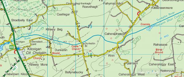
Dunkellin River
Peter