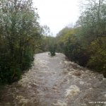
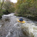
Good Grade 3 river needs plenty of recent rain to make it runnable. After a lot of rain it is good fun. Nice rapids with no big holes but a few minor sticky ones at higher levels. Some shallow spots and you be advised to use a creek boat if its low but when its high definitely bring your playboat.
You can venture higher up in to valley if you wish to find some drops. But don't walk form the Cottage, drive further up and trek across the fields to find what your looking for. Some sizeable drop up here 5,6 7ft but most drop into shallow or boney pools. From Hanora's cottage the river is relatively easy going. Beware of some early over growing tree and bushes most are passable. The fun begins not long after you pass Birtchels Bridge. Rapids are short, not to technical and longish stretches before the next rapids to collect gear(not in high water). Ill put up a more detailed descriptions of the rapids and intervals at a later date with photos. The rapids seem to fade away just before you reach the village where you meet the hay stack waves the next rapids runs to the left and the winds right through a gap that appears to be super narrow but is actually a lot wider as you approach it. Get out in in the pool around the corner on the left.
Trees Another college club lost a number of boats a few years back when running it in high water. Also after prolonged high levels there can be a lot of trees on the river.
HAZARD UPDATE sep 10: From Birtchels bridge for about 3km down river their is a lot of overhanging branches which will be cut soon.very dangerous on very high levels.
None as far as we know. The water is clean and river litter free. Locals love to salute paddlers as they pass by its not often they see us around. Be friendly and respect eh parking areas at the hall and Esp out side the church and Hanora's Cottage (a very popular, expensive restaurant).
No gauges that you can inspect sorry. But if there is just enough water to float your kayak at Birtchels bridge its low to medium and if there is more than enough water to float your boat and its moving fast is high - very high.
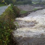
Check out the picnic area at the get out, if the sand beside the stone picnic table is covered, the river is nicely runnable, This river is best run when the water comes up flush with the concrete step .If it starts to rise up the picnic table this is when the overhanging branches are a problem in upper-section.The gorge section from about 2 km up river from Ballymac is a better choice at this level as no trees overhanging.This is when you come to first little bridge and a mud track on left to the river. A pushy grade 3.
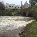
Located in the Nire Valley just off the Dungarvan to Clonmel road at Ballymacarbery. If you are coming from Dungarvan take the first right after you enter the village of Ballymacarbery. Coming from Clonmel drive through the village until you reach Melody's Bar. Take the left here. Continue up this road until you reach Birtchels Bridge. Take the right before crossing the bridge and continue on to Nire Church and Hanora's Cottage Restaurant. You can continue further on up this road to access the tougher stuff up the slopes of the mountain. Alternative put-in: At lower levels, put in at the forestry area on the right just after going over Birtchels Bridge.
In the village of Ballymacarbery you'll find the boarded up old town hall. Park here, the get out is directly across the road down a set of steps to a picnic area with a big eddy and plenty of room to get out.
Interactive map loading...